

Scioto Trail State Park
- May 16, 2020
- 8 min read
Updated: May 25, 2024
Scioto Trail State Park


“No bird soars too high, if he soars with his own wings.” ― William Blake
Scioto Trail State Park is located in Southern Ross County. It has several trails and beautiful views.
The Firetower
When first pulling into Scioto Trail State Park, from 104, there is a historical fire tower. One reason that we choose to visit Scioto Trail State Park was to climb the tower. However, when we arrived, the tower was closed due to the Coronavirus.


Leaving the fire tower, it was unclear on what direction we needed to go. Luckily, we chose the correct way. If you plan on visiting the park and come off of 104, bear to your right around the fire tower. This is Stoney Creek Road. Stay on this road. It takes you to the camping sites and trails.
Stewart Lake
Since the area is confusing if you haven’t been there before, we parked at the first lot we came to. This lot was next to Stewart Lake. So, of course, we walked this trail first.


The Stewart Lake trail is a moderate to easy hiking trail. There are some elevation changes, but nothing crazy. The trail makes a loop around the lake. There is also a trail the breaks off, but it was way too muddy to try.
The lake was quiet, and we didn’t see anyone else. There were several birds flying around and a single pair of geese. The one goose was nesting right next to the trail. It was almost impossible to see her until we came upon her. She was laying on her gosling. We got the death stare, but she let us pass on by.


Firetower Trail
From the Stewart Lake Parking lot, we crossed the road to the walk-in campsite. The site is large and has plenty of trees and shade. There are also pit toilets, potable water, picnic tables and fire rings.


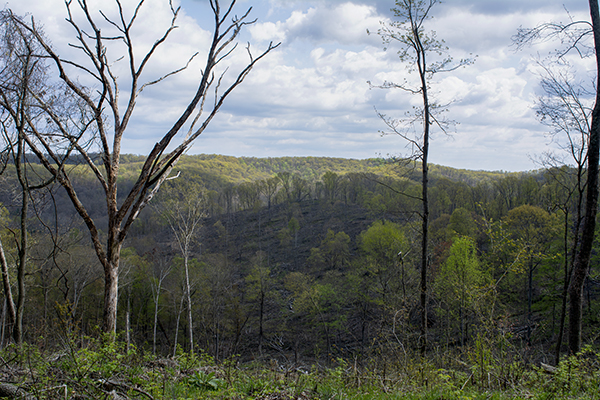
At the back of the campsite is the entrance to Firetower trail. The trail starts off easy and flat, but quickly becomes steep. It is a difficult trail that is very hard to walk. In many places, it looks as though it is just a runoff. There are tree roots, fallen trees, and rocks. Once you get to the top, the strenuous climb is worth it. The views are breathtaking.


The top of the trail flattens off. There is a large clearing where many of the trees have been cut down. However, there were still trees scattering the top. We visited in late April, and the place was alive will birds and butterflies.


Heading around the trail we went from trail marker K, to J, to I. The trail had a gradual decline. It was completely surrounded by the woods. It ended at Caldwell Lake.


Caldwell Lake
The Caldwell Lake area had quite a few people fishing. There was also a couple in kayaks. This area has plenty for people to do. There is an RV camp, playground, horseshoe pits and a beach.


Please note the Do Not Feed The Geese sign. To learn more about the dangers of feeding bread to birds click HERE.
We walked around the southwest side of the lake. The trail was a muddy mess that was almost impassible in areas. We passed a midland painted turtle and a beaver dam.


From Caldwell Lake, we walked down the steps to a parking area near the park maintenance. The horse shoe pits are located near the bottom of the stairs.


Scioto Trail Bridle Trail
Near the back of the park maintenance building is the entrance to the Bridle Trail. This trail is for hikers, bicycles and horses. The trail was very hard to walk since it is used for horses as well. The trails were pure mud and very slippery.


The trail crosses Stoney Creek Road. Once we crossed over, we came upon a creek. There was no bridge and the water was deep and running swiftly. Instead of crossing here, we walked down Stoney Creek Road to Hatfield Road.


Buckeye Trail
From Hatfield Road we were able to get back on the trail. Here it is Buckeye Trail.


Part way down the trail it splits. Horses can go one way; the other way was for foot travel only. This made it a lot easier to walk.


We followed the trail until it got close to the Stewart Lake parking area. There was a trail that split off. However, there was no bridge to cross the creek again. It wasn’t as bad as the last crossing. We made it over without getting too wet. Once we got across and made it farther up, we noticed a footbridge.
At the end of the trail was a nice size shelter house that would be perfect for parties and get-togethers.

Scioto Trail Plaque (Information taken directly off sign)


The woods you are about to enter reflects the natural history of Ohio as well as its grandeur. Yet its present state is a mere shadow of the primeval forest which was once part of the largest deciduous woodland on earth.
The assemblage of plants which comprises the present forests has changed and evolved through time. Approximately 12,000 years ago, glacial ice still lay in the northern reaches of the state. The climate was cooler and wetter and spruce forests thrived at the glacier’s margins. As the ice withdrew and the climate warmed, these boreal forests were not able to compete with the faster growing hardwood trees. The northern species retreated to Canada with only isolated pockets remaining in damp cool gorges.
The climate continued a gradual warming trend until about 7,000 ears ago when temperatures averaged several degrees warmer than present. The grasslands of the Great Plains spread eastward and patches of prairies appeared in the state. Islands of giant bur oak trees swam in thousands of acres of open land.
As the climate moderated, the deciduous forest encroached upon the prairies. Only small remnants were left as the first frontiersmen pushed west into Ohio.
Those who saw the magnificent virgin forest reported that a squirrel could climb into a tress in Pennsylvania and travel all the way to Indiana without ever coming down to the ground. The boles of the ancient trees stood as sentinels across the forest floor darkened by a spreading canopy that blotted out the sun. So little grew in the understory the wary deer could spot a hunting Shawnee a good distance away. Broad streams provided for but a single silver streak of sky, yet they alone allowed a bit of sunshine to touch the rich earth. Giants not rivaled by today’s record trees crowded every hillside and reached for the clouds on the flat western plains.
The early settlers regarded this forest as a somewhat dismal place. They were accustomed to and sought the bright sunny fields of their homelands and they needed fields for crops and logs for cabins. The trees, therefore, began to fall beneath the axe. By 1900, the once expansive forest was reduced to less woodland than we see today.
Areas such as this included in the park have regained mature forest status. The trees are not nearly as large and the understory more crowded, but it again echoes the voice of the woodthrush and renews life each spring with a flourish of wildflowers.
If left to its own devices, nature does not always create a forest as an end product to years of succession. What plant species thrive, replace others, die out, or grow to maturity are determined by a number of factors. Climate, terrain and soil types all play a role in the development of a pattern which will eventually lead to a stable, little changing community, which is to be woodland, bog or prairie. Different conditions even lead to various forest types such as oak-hickory or beech-maple.
Remember the heritage of our woodlands as you follow these trails.
The Underground Railroad


The Sign (Information taken directly off of sign)
The Underground Railroad was neither underground nor a railroad, but a system of loosely connected safe havens where those escaping the brutal conditions of slavery were sheltered, fed, clothed, nursed, concealed, disguised, and instructed during their journey to freedom. Although this movement was one of America’s greatest social, moral, and humanitarian endeavors, the details about it were often cloaked in secrecy to protect those involved from the retribution of civil law and slave-catchers. Ohio’s history has been permanently shaped by the thousands of runaway slaves passing through of finding permanent residence in the state.


The River-to-Lake Freedom Trail
ODOT along with the Friends of Freedom Society have put together a map of the River-to-Lake Freedom Trail. You can find it HERE.
Camping Sites
Scioto Trails State Park has two separate campsites. One site is for RVs and the other is a primitive campsite. Both sites have picnic tables and firepits. The primitive walk-in site has 18 non-electrical sites. The Caldwell Lake camping area has 56 sites. 40 of these have electric.


The RV site is at Caldwell Lake. The lake has a small beach and playground area. You can also find a horseshoe pit just past the lake. This is also where you can find the Campground Store.

There are pit toilets available. We did not see any showers.


Birding
The birding at Scioto Trail State Park in Ohio was great and spring migration was just starting. 147 species have been documented on eBird.
We spotted:


Our Thoughts
Positives
This place is beautiful and is densely forested. The ridge top is breathtaking. There are several trails and plenty of camping spaces, including primitive.
The fire tower is a nice touch. We wish that we could have climbed it.
There are Smokey Bear signs all over the park. And who doesn’t love Smokey Bear?


Negatives
Some walking trails are shared with horses. This is great for riders. But during rainy months the trails are destroyed and almost impassible for hikers.
The roads are not well-marked coming into the park. It would be very easy to turn on the wrong road.
Many of the creek crossings do not have bridges. There doesn’t seem to be any type of reasoning for which crossing does and which doesn’t.
There isn’t any seating available along the trail.
What You Can Expect at Scioto Trail State Park
Please note that park rules and regulations can change at any time. The following information was in effect for Scioto Trail State Park as of May 2020.

The bathrooms are pit style and are located at both campgrounds.

Bicycles are prohibited on some trails.

Great place for birding in Ohio.

There are a few footbridges.

Concealed carry is permitted.

Pets on leashes are permitted. There are some exceptions a Ohio State Parks.

Moderate to extreme elevation changes. We had an ascent of 494 feet, and a decent of 490 feet.

Several blacktop parking areas. ADA spaces are available.

There are picnic tables located in the shelter house and at the camping sites.

There is a playground.

No seating along the trails.

There is plenty of shade available.

A large shelter house is located next to the Stewart Lake parking area.

Trails are marked and easy to see.

Trails are natural.

Primitive and RV camping sites.

We did not see any trashcans. However, camping areas were closed due to the Coronavirus.

Trails cross water in many spots. We recommend that you wear a good pair of waterproof boots when visiting Scioto Trail State Park.

ADA spaces are available. There are parking lots throughout the park.


